Topographic and satellite maps
The base map shows contour lines and trails and can switch to satellite imagery. Several phones are shown at once in different colors, with the latest position labeled.

N-ANYWHERE · IRIDIUM EXTREME PTT
N-Anywhere makes the Iridium 9575 Extreme PTT more than you think
In phone mode, the Iridium Extreme PTT can send its position and text messages back over Iridium. N-Anywhere receives these reports, routes them by number to the organization using each phone, and shows them as tracks on a topographic map and as a conversation. Staff sign in from a browser; nothing to install. With a geofence set, the platform emails your organization when someone inside it goes quiet for too long. When someone enters a weather warning or disaster alert area, an SMS goes to that phone automatically. Alert messages are available in English only for now; a Chinese version will follow.
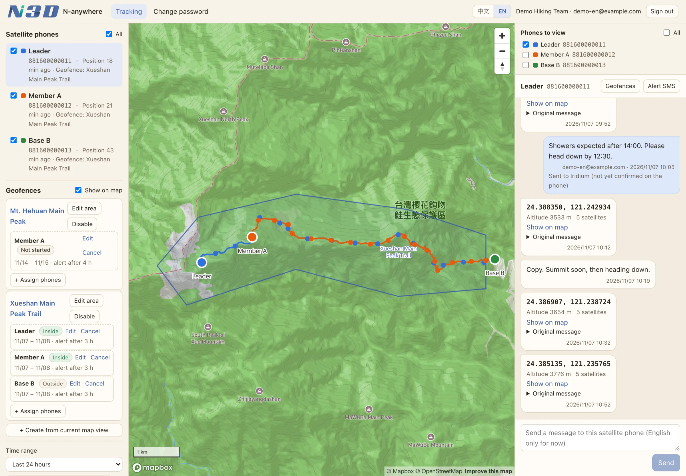
Each phone's last report and current geofence. Ticked phones are drawn on the map.
Saved areas with their assigned phones, periods and current status.
Pick a time range; draw tracks along trails, as smooth curves or as straight lines; add weather layers or satellite imagery.
One color per phone, with the latest position labeled and geofences drawn in.
Positions and text messages in time order. "Show on map" jumps to the spot; tick several phones to merge them.
With one phone ticked, text it straight from the web (English only for now).
Switch the interface between Chinese and English at any time.
The base map shows contour lines and trails and can switch to satellite imagery. Several phones are shown at once in different colors, with the latest position labeled.
Rainfall, temperature and wind can be shown on the map. The data are Central Weather Administration station observations; click a station to see its values.
When reports lie on a trail, the track follows the trail; other segments are joined by a smooth curve. Smooth-curve and straight-line views are also available. The line is an estimate of the route, so search and rescue should rely on the reported positions.
When the gap between two reports is much longer than usual, it is drawn as a dashed line: how that stretch was travelled is unknown. If the phone cannot receive GNSS, Iridium estimates its position automatically, but with a larger offset; these positions are shown as hollow dots and are not joined into the track.
Choose the last 24 hours, 3 days, 7 days or 30 days, or pick your own date range (up to 92 days at a time). The map and the conversation both follow this period.
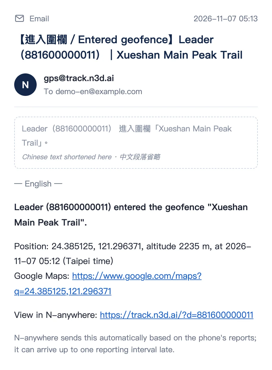
Draw an area on the map and assign it to each satellite phone for the period of a trip. When a phone inside goes quiet for too long, or enters or leaves the area, the platform emails your organization.
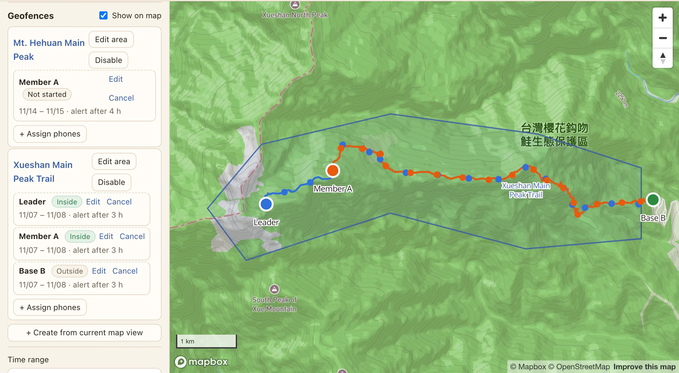
Drag the corners into any shape and reuse it later. Each phone can be assigned to different geofences for different periods; long-term deployments can leave the end date open.
During the period, if a phone inside the geofence sends nothing (no position or text message) for longer than the set time, your organization is emailed, and emailed again once anything arrives. For overnight trips, quiet hours can be set so that time switched off at night does not count.
An email is sent when a phone's reported GNSS position enters or leaves the geofence. This can be turned off.
The platform can only tell that nothing has been received: the phone may be switched off, unable to see the sky or out of battery, which does not necessarily mean an accident. Overdue alerts prompt your organization to check; they do not replace emergency numbers such as 119.
Automatic SMS alerts are not sent to everyone. Each phone is checked against its own reported position: it gets an alert only when it is inside the warning or alert area. For example, if an earthquake strikes the Kaohsiung mountains, a phone in the Yilan mountains does not receive it.
Phones are matched against the townships and counties a warning lists, or the area an alert draws. Earthquakes go by the intensity measured near the phone.
Only the phone's recent GNSS position is used. Positions that are too old, or estimated by Iridium, are left out so nobody gets an alert for a place they have already left.
Each type is sent once in 24 hours. If it becomes more serious (heavy rain to torrential rain, a stronger earthquake nearby) it is sent again. Nothing is sent when an alert is lifted.
When you work in remote mountains or are out on a trail, there is often no mobile signal, and news of an earthquake, torrential rain, a debris flow or a road closure cannot reach you. N3D sends the most important disaster information straight to your satellite phone by satellite. That one message could be what saves your life.
There is nothing to look up and no flood of irrelevant alerts: the platform checks each phone's reported position and sends only what applies where you are. The phone must be on, in phone mode and able to see the sky, and must report its position regularly, to receive these alerts.
Alert messages are available in English only for now; a Chinese version will follow. They are short English summaries the platform writes from what the agencies issue, and the agencies' original text prevails. For example: Reservoir Release RED: Gukeng Township, Yunlin County until 11/02 11:18. Hushan Reservoir, free overflow. WRA
Your organization ticks the types it wants on the platform
Every phone receives these automatically, with no setup
Every phone receives these automatically, with no setup
Data come from the Central Weather Administration (Open Government Data License) and the Civil Alert Open Data Platform of the National Science and Technology Center for Disaster Reduction (the issuing agencies). N-Anywhere is an N3D service, not an official government system, and is not affiliated with these agencies.
However far from shore, typhoon sea warnings, severe thunderstorm notices and high waves are matched against the sea area or zone drawn by the Central Weather Administration.
Alerts that list only coastal townships, such as tsunamis and high waves, treat the boat as being in the nearest coastal township.
Flooding, debris flows, road closures and reservoir releases are not sent to boats at sea.
Positions and text messages appear in time order as a conversation, each with coordinates, altitude and the number of positioning satellites. "Show on map" moves the map there and drops a pin. Tick several phones to merge them into one list in time order.
Each original email from Iridium is stored separately, so every record on screen can be traced back to its source when it needs to be checked later.
Type a message in the conversation and Iridium delivers it to the phone in the field. English only for now; a Chinese version will follow.
Each organization has its own accounts and sees only the satellite phones and records assigned to it. Accounts are opened by N3D, and the password must be changed at first sign-in.
When a satellite phone is lent to another organization, records are assigned by time: those from before the handover stay with the previous organization, and the new one sees only what comes after.
It works in any browser on a computer or a phone and can be added to the phone's home screen; there is no app to install. The interface switches between Chinese and English; place names and phone names stay in their original language.
N-Anywhere will next add Iridium SBD and IMT (Iridium Messaging Transport) satellite data devices. Positions and messages from these devices will appear alongside Extreme PTT phones, on the same platform and the same map. Availability will be announced later.
The Iridium Extreme PTT in phone mode: position reports and text messages. The Icom IC-SAT100 and IC-SAT100M work in push-to-talk mode only, and Iridium does not list location-based services for them; their location sharing is shown only on the screens of radios in the same talkgroup and cannot reach N-Anywhere. Organizations that need tracking should choose the Iridium Extreme PTT.
No. N-Anywhere uses the phone's built-in position reporting and messaging. Staff sign in from a browser on a computer or a phone, and can add it to the phone's home screen.
N3D usually sets the phone up before handover. To set regular GNSS position reports yourself, first make sure the phone is in phone mode, then:
1. Turn on positioning: Menu → Setup → Location Options → GPS Options, and set GPS On/Off to Enabled.
2. Set the interval: Menu → Setup → Location Options → Message Options → Regular Update → Update Frequency, and choose an interval. The default, No Update, sends nothing.
3. Set the receiving address: in the same menu, choose Update Recipient → Options → Edit → Enter Email, and enter info@n3d.ai. Regular reports can have only one recipient.
Each report is a message sent from the phone and is charged under your plan; a shorter interval gives a more detailed track but costs more and uses more battery. Menu names may differ slightly between firmware versions; if you cannot find one, contact N3D.
Yes. Quick GPS sends your current position once, by hand, to up to 5 recipients you set in advance, separately from regular reports. Add info@n3d.ai under Menu → Setup → Location Options → Message Options → Quick GPS List and the position appears in N-Anywhere. To send one, press the Convenience Key on the right side of the phone, wait for a position, press Share and choose Quick GPS.
It depends on the reporting interval set on the phone and on how long Iridium takes to forward the message as email. A report appears on the map once the platform receives it, and the page refreshes every 30 seconds. Delivery of satellite messages depends on sky view and network conditions, so it cannot be guaranteed to be immediate. The platform checks positions against active alerts every minute, so the more often a phone reports, the sooner it is found inside an area.
No. N-Anywhere lets an organization know where its people are and how they are doing. It does not replace emergency numbers such as 119.
Only phones inside the geofence during their assigned period are timed. Counting starts from the last thing received (a position or a text message); once the time your organization set has passed, an email is sent, followed by a back-in-contact email when anything arrives. Alerts can be late by up to one reporting interval, so set the overdue time to at least twice the interval.
No. Each type is sent once in 24 hours. It is sent again only if it becomes more serious, and nothing is sent when it is lifted.
Yes. Inside a warning sea area, typhoon sea warnings, severe thunderstorm notices and high waves are matched by sea area or zone; close to shore, coastal alerts such as tsunamis and high waves are received too. Onshore flooding, debris flows, road closures and reservoir releases are not sent to boats.
Alerts from the Civil Alert Open Data Platform need none: every phone receives them automatically. The 8 Central Weather Administration types are ticked by your organization on the platform; at sea, typhoon warnings and severe thunderstorm notices arrive automatically.
Yes. Alert messages are available in English only for now; a Chinese version will follow. The platform interface switches between Chinese and English.
Pricing depends on the organization and the number of phones. Please contact N3D.